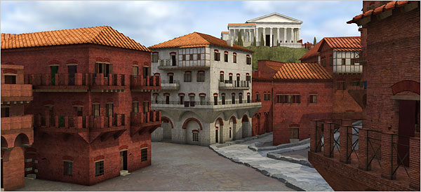
 Google has captured the future. Now it is taking over the past. But that’s not such a bad thing, when it provides new features like this “Ancient Rome 3D” marvel, which, as the NYTimes story shows, has re-created the Rome of Constantine’s era and allows the viewer to fly through its buildings and peruse its streets.
Ancient Rome 3D, as the new feature is known, is a digital elaboration of some 7,000 buildings recreating Rome circa A.D. 320, at the height of Constantine’s empire, when more than a million inhabitants lived within the city’s Aurelian walls.
In Google Earth-speak it is a “layer” to which visitors gain access through its Gallery database of images and information. “In this case the layer is above ground and not below where it should be” from an archaeological point of view, said Bernard Frischer, the director of the University of Virginia’s Institute for Advanced Technology in the Humanities.
For nearly three decades Professor Frischer has been the driving force of an effort to bring ancient Rome to virtual life. The Google Earth feature is based on his Rome Reborn 1.0, a 3-D reconstruction first developed in 1996 at the University of California, Los Angeles, and fine-tuned over the years with partners in the United States and Europe.
Of the 7,000 buildings in the 1.0 version, around 250 are extremely detailed. (Thirty-one of them are based on 1:1 scale models built at U.C.L.A.) The others are sketchier and derived from a 3-D scan of data collected from a plaster model of ancient Rome at the Museum of Roman Civilization here.
Check out the video demonstration of the program before downloading. Inter mirifica, indeed.

